THE National Emergency Management Agency continues to closely monitor the track of Hurricane Ian which forecasters anticipate could bring heavy rainfall to the northwest Bahamas.
The storm is presently located in the Caribbean Sea.
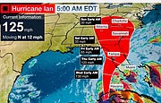
According to an alert on Hurricane Ian issued by the Department of Meteorology at noon yesterday, the storm was forecast to continue rapidly strengthening with rain bands from the hurricane expected to affect The Bahamas last night.
Yesterday, Ian was moving towards the northwest at 13 miles per hour. On its forecasted track, Ian will emerge over the south-eastern Gulf of Mexico today and approach the west coast of Florida on Wednesday.
Maximum sustained winds are near 80 miles per hour with higher gusts. Rapid strengthening is expected during the next day or so and Ian is forecast to become a major hurricane (Category 3 or higher) by early Tuesday.
Forecasters at the Department of Meteorology predict that on its current track, Hurricane Ian will pass some distance away from The Bahamas, but because of its expansive nature, the north-western Bahamas could encounter rainbands that could produce significant rainfall, gusty winds, thunderstorm activity and potential tornadic activity.
The northwestern Bahamas consists of Abaco, Andros, Bimini, the Berry Islands, Eleuthera, the northern Exumas and New Providence.


Comments
Use the comment form below to begin a discussion about this content.
Sign in to comment
Or login with:
OpenID