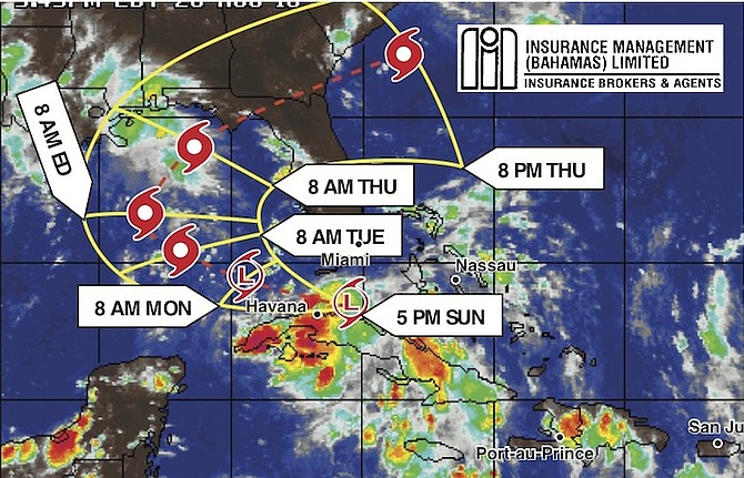
DESPITE threatening to develop last week as it crossed the Atlantic and passed to the west of The Bahamas, a tropical depression was reported by the US National Hurricane Center (NHC) in Miami to have formed finally on Sunday evening south of the lower Florida Keys as it heads into the Gulf of Mexico and turns back towards the northeastern Gulf Coast of the United States.
The NHC said the depression on Monday at at 6am was centred 155 miles west south west of Key West moving west at 9mph with with maximum sustained winds of 35mph with higher gusts. “Some strengthening during the next 48 hours is forecast and the depression is expected to become a tropical storm on Monday,” the NHC reported.
Forecasters for the AccuWeather service predicted conditions would become more favourable to the system for tropical development, starting on Monday afternoon.
The potential exists for the system to organise and strengthen into a tropical depression or storm as it churns into the central Gulf of Mexico early this week and then curves back to the north east. The farther west into the central Gulf of Mexico the system tracks, the greater the potential for development, according to the experts.
Despite the system - Tropical Depression Nine - currently struggling to develop and pushing westward, Florida, Cuba and the eastern Bahamas will remain at risk for increased downpours and locally gusty thunderstorms early this week. The increase in drenching thunderstorms will gradually spread northward across the Florida peninsula into Tuesday, threatening to cause localised flash flooding. Rainfall could reach six inches or more in some locations, especially in the Florida Keys, the far southern Florida peninsula, Cuba and the southwestern Bahamas.
“Where the thunderstorms are more robust, there could be damaging wind gusts, power outages and rough seas,” AccuWeather Senior Meteorologist Alex Sosnowski said. Isolated waterspouts could also form.
Disruptive winds in the atmosphere, interaction with the mountainous Caribbean Islands and dry air prevented the tropical disturbance from organising last week when it threatened the Bahamas, and wind shear (disruptive winds in the atmosphere) is still impacting the system, AccuWeather Meteorologist Ed Vallee said.
With plenty of activity being monitored in the Atlantic over the weekend, forecasters also reported on Sunday that a tropical depression has formed west of Bermuda, bringing the possibility of heavy rain to the coast of North Carolina early this week.
The NHC said the system - Tropical Depression Eight - is located about 230 miles southeast of Cape Hatteras at 5am on Monday and is moving west north west at 10mph. Maximum sustained winds were clocking at 35mph with higher gusts yesterday. The storm’s centre is expected to pass offshore of the Outer Banks of North Carolina on Tuesday night.
Separately, Hurricane Gaston is gathering strength as it moves northwestward in the central Atlantic, but forecasters say it poses no threat to land. The NHC says Gaston reformed as a hurricane on Saturday night.
On Sunday, Gaston had maximum sustained winds of 115mph and was located about 575 miles east of Bermuda, moving northwest at about 1mph. Hurricane-force winds extended outward up to 25 miles from the centre, and tropical-storm-force winds extend outward up to 140 miles
Forecasters say Gaston is drifting and could weaken a little.
A weak area of low pressure near the upper Texas coast is producing disorganised shower and thunderstorm activity over the northwestern Gulf of Mexico and adjacent coastal areas of southwestern Louisiana and southeastern Texas. The NHC does not exepct it to develop significantly.
A tropical wave is expected to move offshore from the west coast of Africa on Tuesday. Conditions are expected to be favourable for development of this system later this week while it moves westward at 15 to 20mph over the tropical eastern Atlantic. The NHC estimates a 50 per cent possiblity that a cyclone will form over the next five days.


Comments
Use the comment form below to begin a discussion about this content.
Sign in to comment
OpenID